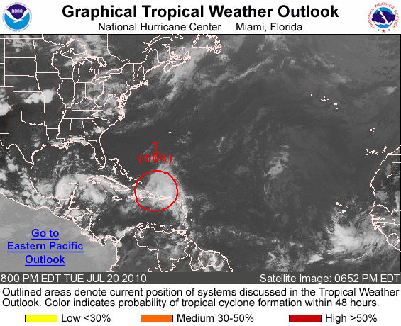

97L keeps getting more and more organized today, as the Hurricane Hunters will go out tomorrow to investigate 97L... This should give forecasters/models alike, a lot more information to work with! While 97L is looking better, it's still being sheared (30-40 knots) by an upper low to the north... Until 97L passes this upper low, I personally don't expect any major development... However, once 97L does pass the upper low, it should start to tap into a outflow jet, which will aid in fairly rapid deepening IMO... The question is, does it have some time, or a lot of time to deepen? Where 97L's center develops, and its early movement is key in the long range track/intensity!

If 97L were to make it into a weak tropical cyclone and strike Southern Florida, I don't think there will be much of a Gulf threat at all... It would be "pulled" further north, and even with a strong ridge in place, there wouldn't be a lot of time for redevelopment! This would most likely lead to a Eastern LA/MS long range landfall... If 97L were to make it through the Florida Straits, then LOOK OUT! In my opinion you would start to see rapid deepening, as what would be Bonnie enters the Central Gulf of Mexico... The ridge across the SE US is very strong, so I think a track towards North-Central Texas/Western Louisiana is very likely... This is a worst cast scenario, but a very likely scenario IMO! We'll know a lot more tomorrow after the Hurricane Hunters investigate 97L!

Right now I'm leaning much more towards a track through the Florida Straits! With a strong ridge in place, this makes the most sense to me! BUT, it really depends on how 97L forms into Bonnie... Where the center forms is KEY in forecasting the track! Again, we should know a lot more tomorrow, as we are in a wait and see mode right now! Everyone needs to watch 97L closely! I have been saying this for a couple of days now, but 97L is NOT something to sleep on!
Quick model overview:
18z GFDL: 55 knots at landfall is very possible across southern Florida, but I do think the track is too far north!
18z HWRF: I like the more southern track, but I think it's a little low with the intensity...
12z Canadian: I actually like this run a lot! I do think the long range track is a little too far east...
18z GFS: I think it looks pretty good in the short term, but it's struggling in the long term... Especially with intensity!
12z ECMWF: Doesn't do much at all with 97L... It that possible? Of course it is! It still has to fight off a strong upper low first, but I do think it at least gets to a weak tropical cyclone before landfall in Southern Florida...
The bottom line with 97L, the more of the Florida mainland what may be Bonnie strikes, the less of an impact in the Gulf of Mexico... Worst case scenario for Southern Florida, maybe a weak hurricane! That's a BIG maybe through, as I think a tropical storm is much more likely! Worst cast scenario if what may be Bonnie moves through the Florida Straits, is a major hurricane moving through the Gulf of Mexico... This is a real threat if "Bonnie" does move through the Florida Straits with minimal impact from the Florida Mainland... This is a very fine line I'm talking about! 50-100 miles will make a HUGE difference! Much more to come tomorrow!
No comments:
Post a Comment