 Myself in Hurricane Katrina (Gulfport, MS)
This year's 2010 hurricane season has the potential to be very active! There are so many factors that come into play and honestly they all seem to tie together like many things in weather... I'm going to hit on 10 factors that will play into this upcoming season...
1) Dying El Nino: El Nino is on life support right now which is not a good sign for the upcoming hurricane season... We are pretty much now moving into a neutral phase and the reversal is happening even faster than I orginally thought! We may be in a La Nina signal as fast as late June/early July according to CFS long range SST forecasts... The 90 day SOI average is down to -1.02 today! Remember the 90 day average was -11 a month ago!
2) Nino 3.4 SST anomalies: It's showing a rapid reversal of the pattern... By July we should be in a solid La Nina signal...

3) Oceanic Nino Index (ONI): The 3 month average has moved from 1.7 (DJF) to 1.5 (JFM) to now 1.2 (FMA)... Values between .4 and -.4 are considered neutral... I personally think we will get to that threshold by as early as the AMJ average! At the worst the MJJ average... Everything is pointing this direction so I don't think my forecast is a stretch at all...
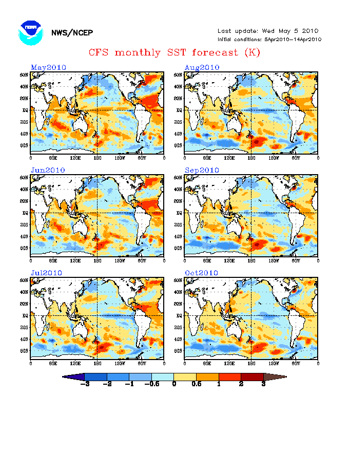
4) Atlantic tripole signature: This is scary looking IMO! You have extremely warm water currently in the MDR, which is forecast to continue and extend into the Gulf and along the east coast of Florida by July... In the north Atlantic you have very warm water as well relative to average... In-between you have colder than normal water in the west-central Atlantic... That's not a good thing to see if you don't want hurricanes... You will enhanced sinking in the colder regions which will enhance the upward motion in the MDR and into the Gulf and east coast of Florida...

5) Interrelated La Nina: This is where everything starts to tie together! You have a very dangerous looking tripole signature in the Atlantic! You will have cold waters developing off the South American coast and into the central Pacific as we enter a La Nina phase by July... Sinking in the Pacific, rising motions in the MDR/Gulf/Florida, and more sinking in the west-central Atlantic... I almost feel like Vince Lombardi when he taught the power sweep to the Green Bay Packers in the early 60's... "What we're looking for is a seal here, and a seal here, and run this play... in... the... alley." You may laugh but that's exactly what is going to happen here... You will have a seal on the Pacific side with a La Nina signature, you have a seal on the west-central Atlantic side with colder than normal SST anomalies, and the alley will be the path of upward motion (warm SST anomalies) directed right at the US... Especially at the Gulf and Florida! I'm telling you, this is NOT a good look!

6) September forecasted SST temps: This is scary to look at as well! You warm the Gulf and the waters off the eastern coast of Florida in June, July, and August... But there is something very disturbing showing up in September! You see a huge cooling of the waters in the Gulf and off the eastern coast of Florida... By October you really noticed this cooling! Do you really think these waters are going to just cool all of a sudden during the peak of hurricane season? I seriously doubt that, as it is most likely showing upwelling/precipitation from multiple tropical cyclones... Off course this is a long ways out and I'm just speculating, but this make a lot of sense to me as it was originally pointing out by Joe Bastardi!
I personally feel this is very scary looking and for the models to show the potential of this occurring months out is again, just scary! Things start to tie together again, and it really does make a LOT of sense if you think about it... I know there is an old saying about rising pressure near Cape Hatteras, especially later in the hurricane season... Something like, 1025 high and look out below (south)... I may not have it exactly right, but basically it just reinforces some of the factors above! If you enhanced the sinking air with rising pressure, then you will have enhanced rising air and lowering of pressure to the south... The weather always wants to reach a balance and it crazy how it all ties together!
7) MJO Forecast: As many of you know, an enhance in rising motions caused by the MJO pulse statically can lead to a 4 x likelihood of tropical development in the Gulf of Mexico and western Caribbean... Off the CPC site, you can get a very useful 15 day MJO index forecast and also the 40 day wave MJO index... To really simplify this, the MJO tends to organize in the Indian ocean where there is a lot of rising motion... As it moves across the Pacific, you can basically follow this rising motion through the 40 day wave and forecast it through the 15 day MJO forecast... When I talk about the 40 day wave I'm talking about how the MJO pulse typically takes 40 days to make it through all 8 octaves representing different areas of the globe... Of course it can move faster or slower depending on a lot of factors..

During an El Nino phase when you have warm waters in the Pacific, this MJO phase almost gets stuck because of the already warm waters and rising motions associated with it... If you think about it, a neutral phase is the best time to use this MJO 15 day forecast since it is not likely to be affected by the warm waters during El Nino or the cold waters during La Nina... In theory, the neutral phase should allow us the best forecast on the movement of the MJO pulse... Since we are now/shortly entering a neutral phase we can probably put a lot of stock into this 15 day forecast! Right now the MJO pulse is in octave 2 and about to enter octave 3... Again, this is really going to simplify things, but in general when the MJO pulse is in Octaves 3,4,5, & 6 you typically have quiet weather as far as hurricane activity is concerned in the Atlantic... When the MJO pulse enters 7, 8, 1, & 2 you typically have more active weather as far as hurricane activity is concerned in the Atlantic... I have found octaves 8,1, and 2 seem to be the best for development in the Atlantic, while octaves 7 and 3 are ok/average!

Is this perfect? Of course not, as I've seen hurricanes develop whether we have MJO rising motions or not... I could be wrong but I'm pretty sure hurricane Charley developed during a "sinking phase/pulse"... However, I've seen this work a lot (2008 season especially)and it will be interesting to track it currently since again we are entering a neutral phase... The 15 day forecast has the MJO pulse almost entering octave 7... So in about 20 days or so we should see enhanced rising motion associated with the MJO pulse in the Atlantic (entering octave 8)... Plus this rising motion should last about 20 days or so... Again, it typically take 40 days for the MJO pulse to move through all 8 octaves when things go smooth like you would typically see in a neutral phase... The precipitation graphical forecast shows the MJO pulse entering the Atlantic about 20 days out, so it will be interesting to see if it verifies... It does make a lot of sense! Also, it will be interesting to see if this will lead to some tropical activity in late May/early June? I know this is very complex and trust me I don't understand everything about it at all, but because of my good friend Justyn Jackson & my internet teacher Joe Bastardi, I have a decent grasp on this.... I hope it made some sense?

8) Saharan Air Layer (SAL): This was fairly quiet a few weeks ago, but I have noticed an increase in coverage recently, even though that is fairly typical for this time of year... Overall, it's not looking like it did last year, but this could potentially be a limiting factor! Hurricanes/Tropical Storms/Tropical Waves don't like the SAL so it will be important to keep an eye on this as we go through the season... I have been told that the rainy season was above normal in north Africa, but I honestly don't know much about this at all (need to research!)... It doesn't look like it did last year, but there is still enough present that we have to watch this closely as it could be a limiting factor for sure! Check back in Aug/Sept when the Cape Verde season really gets going!

9) Negative North Atlantic Oscillation (-NAO): We have had a fairly constant - NAO through a lot of the winter... This is forecasted by many to continue through the 2010 tropical season! If forecasted correctly, it will only add more blocking and help displace the ridge further west... When you add this to many of the factors pointed out above, I not only see a lot of tropical activity, but I also see a lot of landfalling tropical cyclones... Even without a -NAO I still think we would have increased landfalls, but again this will only add to the problem if it verifies!

10) Lack of Wind Shear: This ties back to La Nina once again because typically during a La Nina phase you have less wind shear in the Atlantic/MDR... This is not a good sign and interesting how again it's all interrelated...
In closing there are plenty of other factors I haven't talked about or looked at! However, I hope this was helpful and informative overall! I'm always trying to learn and get better so if you have any constructive comments I would be more than glad to hear them! Again, I'm not an expert at all and I still have a long ways to go, but I really love studying/experiencing tropical weather!!! It's by far my favorite!
In other news we have decided to leave for the Great Plains on Friday... Monday is now looking big, with Tuesday looking fairly big as well... I still think Wednesday and maybe Thursday will be good chase days as well... By the end of the week everything should be fairly washed out/worked over... Again, I would say at least 2-3 good/great chase days with a couple decent/ok ones possible... Sunday has some potential, but you have to worry about the CAP and possible lack of deep moisture... I will say the GFS is bringing moisture back much quicker than it originally was! However, the tele-connections tell me the forcing will be lagging way behind and I'm just not feeling Sunday very much! The GFS is finally catching on and slowing everything down! Either way it's going to be very active next week! After Thursday/Friday it doesn't look good as far as chasing is concerned for about a week... It should come back strong though towards the mid part of May IMO!

No comments:
Post a Comment